

This week in Pennsylvania Archaeology takes us to Tioga
County situated at the northern border of Pennsylvania. Surrounded by Potter,
Lycoming and Bradford counties and the New York state border, Tioga is noted
for its many State and National parks and numerous lakes where residents and
visitors alike enjoy its captivating natural beauty. Segments of the 50 mile
long Pennsylvania Grand Canyon west of Wellsboro and the Pine Creek Rail Trail
wind through Pine Creek gorge and connect with the Susquehanna’s West Branch River
valley at Jersey Shore, Pennsylvania.
Tioga County, formed from part of Lycoming County in 1804
takes it name from the Tioga River. It has a total land surface of 1137 square
miles and Wellsboro is the county seat. Much of Tioga County remains rural and
is the perfect setting for the State’s annual Laurel Festival held each Spring.
The main corridors, 6, 287 and 15, connect much of the countryside with the
more urban towns such as Mansfield, and home to Mansfield University of
Pennsylvania.
Pennsylvanian, Mississippian and Devonian rocks constitute
the geological makeup of Tioga County and originally these rocks were a part of
the vast sea sediments that formed some 290-405 million years ago. Tioga County
is located in the Glaciated High Plateau, Glaciated Low Plateau and Deep
Valleys Sections of the Appalachian Plateau Province. These physiographic land
forms are characterized by eroded hills and generally narrow, steep sided valleys.
The major streams are the Cowanesque and
Tioga Rivers that form as major waterways of the Chemung and the Susquehanna’s
North Branch drainage.
According to Paul Wallace (1971) three major Indian paths
cut through Tioga County. The Pine Creek Path which followed the gorge through
the Pine Creek valley connected Quennashawakee Indiantown with the Forbidden
Path at Genesee. The Tioga Path ran from French Margaret’s Town at present day
Williamsport to Painted Post where it connected with the Forbidden Path. A
third path branched from the Tioga Path and joined with the Horseheads Path at
present day Canton then east to Towanda Indian town on the North Branch at
Towanda, Pennsylvania. These paths were most certainly important trailways
throughout prehistory since they all followed less rugged terrain along north
to south and south to north flowing waterways.
The Pennsylvania Archaeological Site Survey (P.A.S.S.) files
list 163 prehistoric and historic period sites for Tioga County. Of these, the
majority (99) have prehistoric components while the remaining (historic in age)
constitute remnants of domestic dwellings/rural farmstead and a few commercial
and industrial sites principally relating to a 19th and 20th
century origin.
Survey data for settlement patterns is largely
riverine/lowland with 103 of the 163 of
the reported sites grouping into this category. The remaining 46 sites relate to an upland setting environment
where small first and second order streams dominate the landscape. Along with
this data the PASS files also show an expected trend for the prehistoric
utilization of cherts/flints over jasper, rhyolite and quartz simply due to the
availability of these glacially derived lithics from valley terrace and stream outwash deposits. Such lithic
cobble sources would have been readily quarried from these locations throughout
Tioga County.
The prehistoric record, as shown by the PASS data, indicates
that an overwhelming number of Late Woodland, Transitional and Middle Archaic
period sites outnumber sites from the other periods. This is especially
puzzling given the pervasive nature of Late Archaic Period sites versus Middle
Archaic Period sites reported for other parts of northern Pennsylvania and southern
New York State.

Archaeological excavation of Owasco house pattern

Planview of Owasco house pattern
There has been a number of cultural resource surveys
conducted in Tioga County, Pennsylvania, however, for this report, only one
will be summarized here. Data recovery activities at the Mansfield Bridge Site
36TI116, by Louis Berger Group, Inc., was undertaken as the result of a
proposed relocation and alignment of State Route (SR) 6015 at Canoe Camp located
south of Mansfield. The study resulted in the discovery and recovery of new
information pertaining to the prehistory of the Tioga River valley from the
Middle Archaic period through the beginning of the Late Woodland period.

The deepest human occupation level at Mansfield Bridge site
contained remnants of a small camp used by Middle Archaic people. Within this level, archaeologists discovered
bifurcate points, debris from manufacturing and re-sharpening these points and
hammerstones made from river cobbles. Scattered amongst this debris lay poorly
preserved bone fragments , likely the skeletal remains from game animals.
Several small charcoal stained hearths that were also discovered yielded a
radiocarbon age between 7610-8150 BP.

Above the Middle Archaic level at the Mansfield Bridge Site archaeologists
discovered a cultural occupation sealed in alluvium that dated to the Late
Archaic Period at 5100-5400 BP. There, the projectile point forms were
identified as Brewerton side-notched, a common point type found in this region
of the Northeast. The small size of the hearths, the presence of other objects
such as uniface tools, waste flakes and a cluster of cobble tools suggested a
site use as a lithic workshop revisited during brief hunting and gathering
excursions into the Tioga River valley.
Following the Late Archaic visitations, the site was
utilized as a short term camp by Transitional Period groups as was indicated by
the presence of rhyolite and jasper bifaces and chipping debris of Susquehanna
and Perkiomen Broad spearpoint types and hammerstones. A radiocarbon date of
ca, 3500 BP., was obtained from a small hearth associated with these tools.

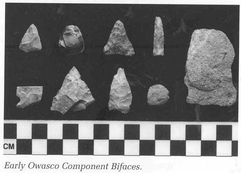
An alluvium deposit capped these earlier non-ceramic bearing
occupations at the Mansfield Bridge Site. A Late Woodland Owasco phase
component with a postmold pattern of a small square-shaped house 25 by 20 feet
in size and pit features surrounding it were identified during the data
recovery project. The occupation was radiocarbon dated to 1000 AD. Chert
triangular points, diagnostic cordmarked pottery and fragments of smoking pipes
link the occupation to the earlier part of the Owasco Carpenter Brook phase
(Ritchie 1965). Other sites of this
phase in New York and the Susquehanna valley of Pennsylvania have been
radiocarbon dated between 1000-1100 AD.

Example of the Mansfield Bridge Site (36Ti116) stratigraphy

Excavation Unit 24 profile with cultural levels
We hope you have enjoyed this archaeology tour through of
Tioga County and please join is next week when we will journey to Union County.
References:
Ritchie, William A.
The Archaeology of New York
State. Natural History Press, Garden City, New York.
Wall, Robert D., Rick Vernay,
Delland Gould and Hope E Luhman
2003 Hunters to Horticulturists: The
Archaeology of the Mansfield Bridge Site. SR 6015, Section D52 Tioga County,
Pennsylvania. Report submitted to the Pennsylvania Department of
Transportation, Engineering District 3-0, Montoursville, Pennsylvania.
Wallace, Paul A.W.
1971 Indian Paths of Pennsylvania.
Second Printing. The Pennsylvania Historical and Museum Commission, Harrisburg.
For more information, visit PAarchaeology.state.pa.us or the Hall of Anthropology and Archaeology at The State Museum of Pennsylvania .
No comments:
Post a Comment