Thursday, December 30, 2010

Red Plains Pipestone: Catlinite ?


When George Catlin, the renowned 19th century artist from Wilkes Barre, Pennsylvania wrote these words …


“The rock on which I sit to write, is the summit of
a precipice thirty feet high, extending two miles in
length and much of the way polished, as if a liquid
glazing had been poured over its surface. Not far
from us, in the solid rocks, are the deep impressed
footsteps the great Spirit (in the form of a track of a
great bird), where he formerly stood when the blood
of the buffaloes that he was devouring, ran into the
rocks and turned them red.” ….Catlin 1859.


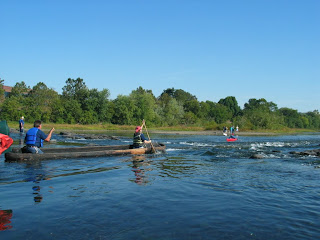
The artist/explorer was describing a Native American legend place on the Coteau du Prairie of southwestern Minnesota which today is called Pipestone National Monument (Figure 1). This location is the place where Native Americans, to this day, quarry the brilliantly colored red stone whose namesake is taken from George Catlin.Catlinite is actually a misnomer term for any easily worked soft red argillaceous stone. It is native to a number of places including South Dakota, Wisconsin and the well known Pipestone National monument region. This material is used in the manufacture of stone smoking pipes, beads and other ornamental objects by Native American cultures; some of which are around 2500 years old (i.e. tube pipes). Much debate has been brought to the forefront regarding the sourcing of Red Plains Pipestone a.k.a. Catlinite (for example see Brown 1989; Gundersen 1987; 1991; 1993; Sigstad 1973).


In Pennsylvania Red Pipestone objects begin to appear archaeologically during the mid 17th century. One splendid example in the collection of The State Museum of Pennsylvania is a calumet style pipe from the Susquehannock Strickler site (36La3) dated at 1645-1665 (Kent 1984). This is the earliest example so far reported from a Native American site in the Susquehanna Valley. The remaining red pipestone objects in the collections that retain known provenience data are additional pipes, beads and pendants – items of personal adornment that relate to 18th century Native American occupations. Representative examples of some of these forms as well as the Strickler site calumet are shown in Figure 2. Red shale objects from the Catskill formation which are similar in appearance to Catlinite were reported at the Summy Site (36Le1) an early Shenks Ferry component (Witthoft 1952). These objects were cut and ground to shape; the complete example was formed into a triangular pendant.


A subjective streak-plate combination Munsell Color test procedure for discriminating differences of Red Plains Pipestone material from Susquehannock and Seneca sites has been completed. This study that suggests the Susquehannock related objects were from quarry sites in Wisconsin and Minnesota and the Seneca site material solely from Wisconsin source(s).

Catlinite is red pipestone, however, not all red pipestone is Catlinite, by definition. Elemental/mineralogical sourcing of the so-called catlinite objects from Pennsylvania would be necessary to determine definitely, their quarry origins so one may only state that the stone from which they are made likely originated from a source(s) somewhere in the mid- Continental United States.

Bibliography

Brown, I.W.
1989 The Calumet Ceremony in the Southeast and Its Archaeological Manifestations.
American Antiquity 54:311-331.

Catlin, G.
1859 Letters and Notes on the Manners, Customs and Conditions of the North American
Indians. Two Volumes in One. J.W.Bradley, Publisher. Philadelphia.

Gundersen, J.N.
1987 Wisconsin Pipestone: A Preliminary Mineralogical Examination. The Wisconsin
Archeologist. 68:1-21.

Gundersen, J.N.
1990 The Mineralogical Characterization of Catlinite from Its Sole Provenience, Pipestone
National Monument, Minnesota. Research/Resources Management Report No. MWR-17.
National Park Service, Omaha.

Gundersen, J.N.
1993 “Catlinite” and the Spread of the Calumet Ceremony. American Antiquity. Comments.
58(3):560-562.

Kent, B.C.
1984 Susquehanna’s Indians. Anthropological Series No.6. The Pennsylvania Historical and
Museum Commission.

Kinsey, W.F. III
1981 Catlinite and Red Pipestone: A Preliminary Report. Paper presented at the Eastern
States Archaeological Federation meeting. Manuscript #12 on file, Section of Archaeology,
The State Museum of Pennsylvania.

Sigstad, J.S.
1973 Age and Distribution of Catlinite and Red Pipestone: 1966. Manuscript on file, National
Park Service, Midwest Region, Omaha.


Witthoft, John and S. S. Farver
1952 Two Shenks Ferry Sites in Lebannon County, Pennsylvania. Pennsylvania
Archaeologist 22(1): 3-32.

Witthoft, John, Harry Schoff and Charles Wray
1953 Micmac, vase-shaped, calumets. Pennsylvania Archaeologist 23(3-4):89-107


For more information, visit PAarchaeology.state.pa.us or the Hall of Anthropology and Archaeology at The State Museum of Pennsylvania .

Thursday, December 23, 2010

The Christmas Tree Point


The Stanly projectile point type was described by Joffre Lanning Coe in 1964 in his definitive work The Formative Cultures of the Carolina Piedmont. Coe characterized it as having “a typical Christmas tree shape”. He found it within a deeply buried context at the Doerschuk site located in North Carolina and dated it to the Middle Archaic period at about 7000 years old.

The Stanly type is not particularly distinctive in that it is simply a straight stemmed point with a slight notch in the base (not to be confused with the sort of basal treatment indicative of the bifurcate point). Sometimes it is serrated but it does not have a ground base like many Early Archaic point types. As noted by Coe, Stanly points can be confused with points from later periods that have been re-sharpened. Coe felt that the point type had morphological parallels with the earlier Archaic Kirk type, thus suggesting a period of cultural continuity spanning two millennia.

Although not particularly common, the Stanly type is found at stratified sites as far west as the Ice House Bottom site in Tennessee and as far north as the Neville site in New Hampshire. It is stratigraphically found above bifurcate points but below Morrow Mountain/Stark points, both broad bladed stemmed points. The Neville site was excavated by Dena Dincauze who felt that the projectile points found there were slightly different from Coe’s definition for the Stanly type and named them Neville points. At the Neville site the point type was associated with atlatl weights and full-grooved axes. Using carbon 14 dating of charcoal, she was able to bracket the component to between 7015 and 7740 years ago.


The largest stratified Stanly site in Pennsylvania presently known, is the West Water Street site (36Cn175) in Lock Haven along the West Branch of the Susquehanna River. This was excavated by Dr. Jay Custer of the University of Delaware. He recovered a total of 47 Neville/Stanly points which represents over 80% of the Middle Archaic points from the site. The occupation at West Water Street was dated at 7390 + 110 years ago (Beta-63528). The makers of these points where not especially discriminating when selecting lithic materials and instead used whatever was locally available. This is in clear contrast to what was the norm for Early Archaic people who frequently traveled great distances to acquire better quality lithics for making projectile points. As well, based on lithic utilization, their territories were smaller, perhaps half the size of Early Archaic territories. Other stratified sites producing Stanly/Neville points in Pennsylvania include, the Memorial Park site also in Clinton County, and the Treichlers Bridge site located in the Lehigh drainage of Northampton County.


One would have to agree that the name “Christmas Tree”, whether it be a formal designation for a projectile point type or a Yule tide symbol, has been around for a very, very long time.


Custer, Jay F., Scott C. Watson, Daniel N. Bailey
A Summary of Phase III Data Recovery Excavations at the West Water Street Site (36Cn175) Pennsylvania Archaeologist Volume 66 Number 1 (1996)
Custer Jay F.
Classification Guide for Arrowheads and Spearpoints of Eastern Pennsylvania and the Central Middle Atlantic Pennsylvania Historical and Museum Commission (2001)
For more information, visit PAarchaeology.state.pa.us or the Hall of Anthropology and Archaeology at The State Museum of Pennsylvania .

Friday, December 17, 2010

City Island Cache

In the late 1980s, the City of Harrisburg began to experience an economic rejuvenation under the driving force of the newly elected mayor, Stephen Reed. One of his projects was the revitalization of City Island, situated in the middle of the Susquehanna River. He proposed a new parking lot, a new baseball stadium and a variety of other attractions. At one point, he proposed a hydroelectric dam that would turn the river into a lake, flood part of the island but encourage more recreation. Another proposed project was the Sports Hall of Fame. Federal permits were necessary for these proposed projects and because it had long been known that the island was inhabited by prehistoric peoples archaeological surveys were conducted under section 106 of the National Historic Preservation Act.


To shorten a very long story, much of the outer margin of the island (200-300 feet) and the southern section below Market Street consisted of recent flood deposits. The northern section above the Walnut Street Bridge was largely disturbed by a series of baseball stadiums and a large water treatment plant. However, located in the center of the island is a well stratified archaeological site recorded with the Pennsylvania Archaeological Site Survey (P.A.S.S.) files as 36Da12. The City of Harrisburg supported several seasons of testing in this area and the Bureau for Historic Preservation continued to conduct public excavations during Archaeology Month until 2004 when the focus of excavations were moved elsewhere.
Site 36Da12 contains components that range from a Middle Archaic bifurcate point occupation beneath eight feet of alluvium to a light scatter of Late Woodland artifacts in the plowzone directly under the macadam parking lot. The most intensive occupations, however, occurred during Late Archaic times, characterized by numerous fire-cracked-rock hearth features replete with net sinkers and straight stemmed projectile points.


One of the most spectacular features recovered from the island was a cache of nine stone artifacts consisting of celts, celt blanks and an axe blank. These were found in a tightly stacked arrangement that was seemingly placed in a small hole. A straight stemmed point was found near-by and radiocarbon dating places the feature’s age at about 4000 BP.
Feature 26 in situ

The cache is interesting for several reasons but one of the most striking is that it seems to combine two technological traditions - celts and axes - that archaeologists once thought were from different time periods. Celts are axe-like implements, 10 cm. to 15 cm long, rectangular in shape, and usually highly polished. The cutting edge or bit could be straight or curved and the poll end was frequently tapered. They usually occur in the Woodland Period, but especially in the Late Woodland. They are believed to have functioned as small hatchets although edge wear patterns suggest they were used on soft materials as associated with skinning and butchering of animals. Axes are usually much larger, weighing five or ten pounds and up to 40 cm long. They were hafted into a handle facilitated by a groove pecked into the pole or blunt end of the tool. These are frequently ground and polished into shape. Stone axes were clearly used in heavy duty cutting activities and frequently show damage on the bit end. During the Middle Archaic Period they usually exhibited a full groove, however, by Late Archaic times, axes were usually only ¾ grooved.

Archaeologists classify celts and axes as ground stone tools, although they are also known as pecked and polished stone tools, these descriptive terms refer to how they were made. Celts and axes were either made from large flakes cleaved from river cobbles or from cobbles that are similar in size and have a general shape of the desired finished product. Native Americans in this region frequently chose dense volcanic or metamorphic rocks for these tools. The first step was to chip them into the general shape of the tool called a preform. This was followed by hammering the piece (called pecking) with a hammerstone until all of the flake scars were removed and the piece achieved it’s near final form. Axes have a groove for hafting and this would be pecked into the pole end running perpendicular to the long axis of the tool. Essentially the entire surface was crushed by this pecking process enabling the final step of polishing. Polishing was completed using a fine textured rock or a mixture of sand and lots of water to achieve a smooth finish. This process was especially important for the bit end. It is important to note that for an average size implement such as those from the City Island cache, this process of chipping, pecking and grinding and polishing could easily require twenty hours or more to complete. Axes start off very large, 30 to 40 cm long and are gradually worn down in size through re-sharpening the bit subsequent to breakage and dulling. The pole end of an axe frequently shows damage from being used as a hammer. It is unclear, how or if, celts were hafted. One experimental form designed and successfully used in the construction of several dugouts (Carr, McLearen, Herbstritt, Johnson 2006) consisted of inserting the pole end of the celt into a large wooden handle.

The Cache Discovery:

The celt/axe cache designated Feature 26 was recovered from within an area of the site near the bottom of a buried A horizon. The artifacts were stacked in parallel fashion, aligned northwest by southeast. This feature measured 27 cm north-south, 32 cm east-west and was 18 cm deep. The smallest specimens were placed on the top of the larger ones, with the largest on the bottom. Two nearly finished celts were on top, followed by the five other blanks. Located on the bottom was a very large flaked stone biface, and a large unfinished axe.


Top image is map from the field of cache in situ prior to removal. Bottom image is recreated based on field record.


The two nearly finished celts have been pecked over most of their surface. The polishing had begun on the bit half. Both implements are made from finegrained sandstone. Based on the presence of cortex, both of these originated as flat cobbles approaching the size and shape of the finished product. One of these (Cat. 1250.1) is plano-convex in cross-section and could have functioned as an adze. The other (Cat. 1250.7) is biconvex in cross-section and could have functioned as an axe or some sort of a defleshing tool.


Catalog #1250.1


Catalog #1250.7


Five specimens appear to be preforms or celt blanks. One of these is rectangular in shape, but rounded on both ends (Cat. 1249.1) and minimally trimmed along the edges. This implement could also have been made from a flat cobble. The other four are large flakes and at least two retain their cortices from the original core or block of material. All are narrow and thick and seem to have been initially struck or formed, using large hammerstones. The flaking morphologies of these preforms range from extensive bifacial flaking to minimal trimming on the ventral surfaces. Three of these (Cat. 1250.2, 1250.3 and 1250.4) are plano-convex in cross-section. The fourth example is the most extensively flaked bifacial piece (Cat.1249.2) and is bi-convex in cross-section.


The largest piece from the feature is an argillite/hornfels flake (Cat 1250.5), 34 cm in length and 3.6 cm in thickness. Based on its width to thickness ratio, this example could have been produced by a soft hammer or a massive wooden billet. The bulb of percussion has been removed and the bifacial edge has been minimally worked. The intended use for this piece is unknown.

Catalog #1250.5


The last specimen is an unfinished axe of finegrained sandstone (Cat. 1250.6). The body has been chipped into shape and the bit end pecked but not polished. The groove was not started but the overall shape is that of an axe and not a celt. Interestingly, six meters to the east, in the same level another unfinished axe (Cat. 1398.1) was recovered. The bit end had been chipped, although smashed by subsequent hammering, and a groove was started on one face.


Catalog #1250.6 Unfinished Axe


Catalog #1398.1 Unfinished axe, Not part of cache

The cache feature demonstrates that celts and axes were being made by the same people and were used during the same time period. However, the obvious question is why were these artifacts from Feature 26 neatly stacked, placed in a hole and never retrieved? They probably represent 50 to 75 hours of work. This cache inspired us to build several dugout canoes but we will never know what was on the minds of the prehistoric technologists who left these behind over 4000 years ago.

We would like to thank Bob Smith (retired geologist from the Pennsylvania Geologic Survey) for identifying the lithic material types of these artifacts. He has helped us many times over the years and we sincerely appreciate his detailed descriptions of lithic types and where they may have originated.

For more information, visit PAarchaeology.state.pa.us or the Hall of Anthropology and Archaeology at The State Museum of Pennsylvania .

Friday, December 10, 2010

Mysteries of the Tuaoi Stone of Atlantis

Every few years, inquiries about a mysterious object make their way through the offices of the State Museum. We’re here to set the record straight that this object is not, nor has ever been, in the possession of the State Museum of Pennsylvania. This week’s blog is courtesy of one of our volunteers in the Section of Archaeology, Addison Warner. Addison has an interest in Meso-American archaeology, and “volunteered” to write about Pennsylvania’s connection to the Maya culture. Enjoy this short piece about the mystery surrounding this unusual object from south of the border.

Cayce Power Stone


It has been rumored for many years that the Tuaoi Stone, also known as the fire stone or emblem stone, the all powerful Atlantean crystal, is hidden amongst the collections of the State Museum of Pennsylvania. Atlantis is the mythical continent that according to Greek legends existed in the middle of the Atlantic Ocean. As the legend goes, the inhabitants were the most technologically advanced culture in the world. Just before the continent sank into the ocean in a fiery explosion, a few Atlanteans escaped to the four corners of the earth, taking with them, the concept of pyramids, agriculture and the wheel.

Yet today, there still remains a mystery as to who possesses this powerful stone and where it remains hidden. It has been purported that this stone possesses the power to provide energy for daily life, rejuvenating the human body to a younger state. Legend has it that it will allow for harnessing fusion fuel from the sea water and even reduce the gravity on certain objects. These are just a few of the stone’s supposed powerful abilities. One can see the desire for our modern culture to locate and exploit its power.


During its final collapse around 10,000 B.C., the inhabitants of Atlantis spread their culture and knowledge throughout the world. They brought with them the power of the Tuaoi Stone to the Maya culture, in what is now modern day Guatemala and the Yucatan region of Mexico. This is where the Tuaoi stone was reported to be rediscovered in the early 1930’s by an American prophet Edgar Cayce. According to Cayce’s writings the crude crystal was unearthed by E. R. Johnson during excavations from 1931-1938 in a Maya site called “Piedras Negras”, in the Northern Guatemalan lowlands. Johnson was in collaboration with the Pennsylvania state museum and the emblem stone was given to the Pennsylvania state museum following the 1933 field season. According to the State Museum of Pennsylvania’s records, no archaeological excavations were ever conducted by the State Museum in the region of the Maya culture. However, archaeologist Dr. John Alden Mason from the University of Pennsylvania conducted several excavations in Central America in the early 1930’s. In coordination with the University of Pennsylvania, they claim that no such stone was ever given to them or is in their possession. This remains a huge mystery for believers of the lost continent of Atlantis. Both the State Museum of Pennsylvania and the University of Pennsylvania have no knowledge of such an artifact existing or being in their possession. So where is the mysterious Tuaoi stone? Who possess its power… and where does it remain hidden? These are questions that will fuel the fire for further investigations as to what really happened to the Tuaoi stone itself and the lost culture of Atlantis.

Next week’s entry promises to be free of crop circles, UFOs or any other wingnut conspiracy theories that may be out there. Until then, stay scientific.


For more information, visit PAarchaeology.state.pa.us or the Hall of Anthropology and Archaeology at The State Museum of Pennsylvania .

Friday, December 3, 2010

Antler Flakers


Figure 1, antler flakers

Among the essential media utilized by Native American cultures for making tools for daily use were the horns from deer, elk and other cervids living around them. Much of this material, better known as antler was worked and shaped by carving, scraping, grinding and smoothing with stone tools and in more recent times with tools of iron such as axes, knives and other similar items obtained through trade with Europeans after their arrival in the New World. Many of these objects are found in the material record when archaeologists investigate Native American habitation sites through careful excavation.

In Pennsylvania and other parts of eastern North America some of these antler objects were used to make something else – in a manner of speaking, tools to make tools. Examples of this are the so-called “antler flakers” used to knap arrowheads and other stone tools (Figure 1). These unique tools are remarkably uniform in shape and size from region to region. Antler flakers, however, vanish from the archaeological record by the mid-1630’s when their utility becomes obsolete due to new innovations in Native American tool kits . Coupled by a cursory search of the files and repository at the State Museum of Pennsylvania’s Section of Archaeology and a review of the literature on the topic provides us with information on a sample of these objects which follows.

Free-hand pressure chipping of the Klamath Indians. (Schumacher 1877)


For comparison, data from three cultural regions around the Finger Lakes of New York and, the lower Susquehanna of southcentral Pennsylvania were used that provide us with some interesting insight on antler flakers. During the early to mid-sixteenth century antler flakers show up on early proto-Mohawk sites located in the Mohawk valley of eastern New York. There, three sites, Garoga, Klock and Smith-Pagerie yielded ten antler flakers, a small number when compared to compilations from other sites (Funk and Kuhn 2003). At a fourth Mohawk site, the Rice’s Woods site dated to the AD 1580 -1614 period, six additional antler flakers were found all sharing similar morphological attributes (Snow 1995; Figure 5.26).

Within the Seneca sequence (Wray 1973) antler flakers have been found at five early proto-historic Iroquois sites where they are apparently common, in fact, quite common (Wray et al. 1987; 1991; 2001). At the Adams, Tram and Cameron sites, Seneca settlements occupied in the late 16th to possibly the earliest decades of the 17th century, the morphology of antler flakers mirror that which is found in the Mohawk data, albeit present in greater frequency. These variations in the data might best be explained by differences in the provenience data of the two regions (ie. middens vs. cemeteries).

Bone chipping implement of the Eskimo (Murdoch 1892)


In the lower Susquehanna valley, antler flaker data from the Susquehannock occupations at Schultz and Washington Boro village sites show a similar chronological pattern when comparisons are made with the New York sites, especially Seneca and the later Rice’s Woods Mohawk site. Excavations conducted at the Schultz and Washington Boro sites in the early 1930’s (Cadzow 1936) and again at Washington Boro in the early 1950’s (Witthoft nd.) followed again at Schultz in the 1970’s (Smith 1970; Casselberry 1971; Kent 1984) provide us with the largest sample of antler flakers for Susquehannock. For villages of the lower Susquehanna valley the majority of these tools were found in the middens and trash pits of the longhouses and near the palisades where the Susquehannocks would go to build their settlements.

Why do antler flakers disappear from the archaeological record around the beginning of the 17th century? The reason simply may be the change in tool technologies of the Native Americans at that time. With the infusion of European made trade kettles beginning around AD 1615-1625 stone arrowheads were rapidly being replaced with metal tipped arrow heads fashioned from cut kettle scraps made in the shape of their stone age predecessor. These small bit lethal weapon tips begin to turn up at the beginning of the 17th century. By the second to third decade of the 17th century metal arrow points are extremely common on all Iroquoian sites. By the third decade of the 17th century a few sites begin to yield evidence of guns which were beginning to be introduced into the native material culture in exchange for furs and other desired commodities. By the 1640’s (post Washington Boro Period) guns were largely the preferred weapon of choice of the Native American. Eventually bow and arrow technology was replaced by these new inventions which negated the need for the antler flaker.

References:

Cadzow, D. A.
1936 Archaeological Studies of the Susquehannock Indians of Pennsylvania. Safe Harbor Report No.2. Pennsylvania Historical Commission, Harrisburg.

Casselberry, S.E.
1971 The Schultz-Funk Site (36LA7): Its Role in the Culture History of the Susquehannocks and Shenks Ferry Indians. Doctoral thesis. The Pennsylvania State University, University Park.

Funk, R.E. and R.D. Kuhn
2003 Three Sixteenth Century Mohawk Iroquois Village Sites. New York State Museum Bulletin 503. The University of the State of New York. The State Education Department, Albany.

Kent, B. C.
1984 Susquehanna’s Indians. Anthropological Series No.6. Pennsylvania Historical and Museum Commission, Harrisburg.

Murdoch, J.
1892 Ethnological Results of the point Barrow Expedition. Ninth Annual Report. Bureau of American Ethnology. Pp.19-441. Washington.

Schumacher, P.
1877 Methods of Making Stone Weapons. Bulletin of the U.S. Geological and Geological Survey Terr. Vol .3 pp. 547-549. Washington.

Smith, I.F.
1970 Schultz Site Settlement Patterns and External Relations: A Preliminary Discussion and Possible Interpretation. New York State Archaeological Association Bulletin 50: 27-34.

Snow, D.R.
1995 Mohawk Valley Archaeology: The Sites. Volume 1. The Institute for Archaeological Studies, University at Albany SUNY, Albany

Witthoft, J.
Nd. Unpublished Field Notes – Eschelman Site (36LA12). Section of Archaeology, The State Museum of Pennsylvania.

Wray, C.F.
1973 Manual for Seneca Iroquois Archeology. Culture primitive, Inc. Rochester.

Wray, C.F. et al.
1987 The Adams and Culbertson Sites. Research Records No. 19. Rochester Museum and Science Center. Rochester.

Wray, C.F. et al.
1991 Tram and Cameron: Two Early Contact Era Seneca Sites. Research Records No. 21. Rochester Museum and Science Center. Rochester.

Wray, C.F. etal. 2001 Dutch Hollow and Factory Hollow: The Advent of Dutch Trade Among the Seneca. Research Records No. 24. Rochester Museum and Science Center. Rochester.

For more information, visit PAarchaeology.state.pa.us or the Hall of Anthropology and Archaeology at The State Museum of Pennsylvania .

Wednesday, November 24, 2010

Talking Turkey


Once again we turn our thoughts towards Native peoples and the first Thanksgiving celebration. Last year when we wrote this blog we discussed the three sisters, corn, beans and squash and their likely spot on the table. This year, our focus will turn to the main course of the celebration on most dinner tables in the United States for at least the past 100 years- the Turkey. Thanksgiving did not become a National Holiday until 1863 when President Lincoln issued a proclamation declaring the date as the last Thursday in November.
Much has been written about the foods served at the first Thanksgiving and a record of the event published in 1622 (Mourt's Relation)refers to the gathering of “fowl” which likely included wild ducks, geese, quail and other game. The pilgrims referred to all birds as “fowl” and did not make a distinction of turkey so we can not determine with any certainty if turkey were actually part of the celebration.

Archaeological excavations have yielded the faunal remains of turkey (Meleagris gallopavo) at most Native American sites of the Late Woodland period. An interesting assemblage from the Eschelman Site, Lancaster County provided evidence of the butchering and processing methods employed by Native peoples. Eschelman Site was the midden or “garbage dump” site for the Susquehannock Washington Boro Village which dates from approximately 1600-1625. The population estimate for this village is roughly 1700 (Kent 1984) based on archaeological evidence of house size and stockade lines. This was a fairly large population which would have required a varied food supply.

The species present in this assemblage include the usual deer, bear, beaver raccoon and turkey to identify a few of the more dominant. Formulas that have been developed for estimating “minimum numbers” (MNI) of species were employed in producing the following data.


Butchering marks visible on the faunal assemblage indicate that turkeys were either skinned or plucked and then butchered to remove heads, feet and wings at the shoulder joint. The bird was then placed whole in a pot until the meat was removed and the bones were “boiled clean”. No cut marks were present on femora, dorsal vertebrae or sternums and no charring or scraping marks were visible.


The relatively high number of turkey available in this collection brings about the question of whether this is a normal or high percentage in comparison with other Susquehannock sites. Of the analyzed data available it would appear that this is a higher than normal percentage of turkey represented. The following table compares the minimum number of individuals (MNI) for each of the five taxons previously identified in the assemblages from four Susquehannock sites.


While the data suggests that turkey played a larger role in the diet of Native peoples in the period from 1600- 1625, it is also understood that the assemblage from Washington Boro, the Eschelman midden site may contain a larger sample size due to the nature of the site. The pattern though does raise some interesting questions in the role of village size and demand on the turkey population. Strickler site population is estimated at 2900 (Kent 1984) an increase of 1200 people since the Washington Boro site. The population of Susquehannocks declines after about 1660 and estimates drop to 900 individuals for the Byrd Leibhart site. Could demand have exceeded supply and thus fewer birds were available to the residents of Byrd Leibhart?

Historic accounts document over hunting of turkey by early settlers which led to a rapid decline in the species. By the early 1800’s the population was almost eradicated as hunters harvested them without any regulation. The remaining birds were found in the central counties in the ridge and hill top woods of Pennsylvania. Demand for lumber and the resulting stripping and deforestation of “Penn’s Woods” further decimated the flock.

The creation of the Pennsylvania Game Commission in 1895 and efforts to regenerate forests saved the estimated few thousand birds from complete extirpation. It was not until 1905 that a limit of one turkey a day for a six week hunting season was introduced. Various methods were employed over the next fifty years including the raising of turkeys by the Commission for release and wildlife management practices. This increased regulation and population supplements led to the first state wide hunting season in 1954. Ten counties did not have a natural population of turkey and those areas were supplied with “game farm raised” turkeys. Careful control over the next fifty years and the “trap and transfer” program implemented by the Game Commission restored the turkey population and led to the elimination of turkey farms operated by the Commission.


Whether the turkey was actually part of that first Thanksgiving is debatable, but what is not in question is its important role in the history of this Commonwealth. Most of us will partake of a turkey from our local grocer or farm market, but for those lucky enough to bag a wild turkey be thankful for the foresight of the Commission in preserving these impressive birds. The following quote from Ben Franklin summarizes the majesty of this bird and his rightful place in history-

Ben Franklin wrote to his daughter regarding his disappointment that the Bald Eagle was chosen over the turkey as the National Bird.

"For the Truth the Turkey is in Comparison a much more respectable Bird, and withal a true original Native of America . . . He is besides, though a little vain & silly, a Bird of Courage, and would not hesitate to attack a Grenadier of the British Guards who should presume to invade his Farm Yard with a red Coat on.”


Kent, Barry C. 1984. Susquehanna's Indians. Anthropological Series No. 6 Pennsylvania Historical and Museum Commission, Harrisburg.

Guilday, J.E.,P.W. Parmalee, and D.P. Tanner. 1962. Aboriginal Butchering Techniques at the Eschelman Site (36La12), Lancaster County, Pennsylvania. Pennsylvania Archaeologist 32(2):59-83.

For more information, visit PAarchaeology.state.pa.us or the Hall of Anthropology and Archaeology at The State Museum of Pennsylvania .

Friday, November 19, 2010

Compliance Archaeology

We’re busy folks here at TWIPA and we’d like to think we do it all, but we know that’s not the case. With our field season at Fort Hunter finalized and all the pomp and circumstance of Archaeology Month celebrations dispensed and comfortably in the rear view mirror, the staff of the State Museum Section of Archaeology can return to the business of managing and curating the archaeological collection of the Commonwealth for its citizens, now approaching 5 million individual artifacts. What are these artifacts, where did they come from, why are they sent to the State Museum of PA?


These are some of the typical questions we hear from people not familiar with the state of archaeology as its practiced today in Pennsylvania and across the nation. It is a difficult task to fully explain the context in which the majority of archaeology these days takes place in the span of a 700 word or so blog post, but it is important stuff so we’re taking a stab at it anyway. We’ve touched on this topic in several previous posts so if you have the time we encourage you to do a little “digging” through the TWIPA archives.

Most archaeology today is conducted prior to some type of development; roads, bridges, housing subdivisions, dams, prisons, railroads, post offices, courthouses, pipelines – you get the idea. All of these projects have the potential to disturb or destroy archaeological sites. Fortunately, Section 106 of the National Historic Preservation Act of 1966 created a framework as part of any federal undertaking by which sites can be identified, evaluated, and if warranted, destructive activities mitigated. In a nutshell NHPA acknowledges that it is in the best interest and to the benefit of the American people (current and future generations) that significant cultural resources, historic and prehistoric, be documented and preserved where possible. It also recognizes that federal agencies have a responsibility to take into account adverse effects their development projects may have on these significant cultural resources. If this is beginning to sound like contorted legal mumbo jumbo, we apologize, but that’s what it is.


While the artifacts themselves are the property of the landowner on whose land the site was excavated, in Section 106 projects the information recovered, the data (the field forms and notes, artifact inventories, photo documentation and reports) is owned by all of us, as we the taxpayers are ultimately footing the bill for not only the development but also the preservation efforts.


More often than not, the landowner understands the artifacts have more scientific value than they do monetarily, and generously donates them to the State Museum where they are incorporated into a comprehensive database and made available to researchers the world over for a wide variety of scholarly studies, as loans to local historical societies, and of course permanent and temporary exhibits both large and small in the Anthropology and Archaeology Gallery of the State Museum, as well as other historic sites administered by the Pennsylvania Historical and Museum Commission.


One common criticism directed towards archaeologists is that results from these excavations are not shared with the public often enough or in a timely manner. Doing our bit to dispel this shortcoming, we’ve contacted some good people at PennDoT, and they were all too happy to pass along a link to popular publications here , resulting from transportation projects. The page is a little buried, then click "kids page" and then click "highways to archaelogy".


This week we’re highlighting a few of the unsung heroes of Cultural Resource Management (or CRM for those readers who don’t have enough acronyms in their life) the archaeological foot soldiers in the trenches, literally, doing battle with deadlines on compressed time tables, emaciated budgets and inclement weather – just to name a few typical obstacles. While we can’t claim these woes, or any others for that matter, are bedeviling this particular project, its recent appearance in the news seemed to make it a timely and appropriate example of Pennsylvania CRM archaeology. Currently underway is a road re-alignment near the borough of Macungie in Lehigh County, and people are curious and asking questions, and that makes it the perfect opportunity for the archaeology community to engage the public and hammer home the message that archaeology is good for them.


For more information, visit PAarchaeology.state.pa.us or the Hall of Anthropology and Archaeology at The State Museum of Pennsylvania .

Friday, November 12, 2010

Archaeology Day at the State Capitol

Wrapping up our celebration of Archaeology Month in Pennsylvania this year was the annual Archaeology Day at the State Capitol on Monday November 8th, held in the East Wing Rotunda. With so much happening in the world of archaeology, we just couldn’t contain everything to the month of October. Archaeology Day at the Capitol is one of the few times a year when the archaeological community has the opportunity to interact face to face with elected officials to impress upon them the value of archaeology and “make the case” for bolstering legislative support.

An additional aspect of the program included undergraduate students from Indiana University of PA, Edinboro University of PA and West Chester University presenting posters on recent archaeological fieldwork from their respective institutions. State Museum Section of Archaeology staff was also on hand with a new poster highlighting the past five field seasons of investigations at Fort Hunter Mansion and Park. The now nearly-famous cannon ball recovered there in 2008 was also on display.


Invited as featured guest speakers, Neil and Francine Patterson of the Tuscarora Nation gave a special presentation to third and fourth graders from St. Stephen’s Episcopal School and 7th graders from the Catherdral School in Harrisburg. Students were introduced to the heritage and culture of the Tuscarora including learning the difference between native corn and modern hybrid varieties, and the significance of wampum to native peoples. Thanks to Neil and Francine for making the trip from upstate New York to share their history of the Tuscarora with us.

Afterwards the students participated in an exercise to produce cordage, an everyday yet essential material in prehistoric technology. Hands-on activities such as this engage young people and can open the door to an enriched appreciation for indigenous cultures.

For more information, visit PAarchaeology.state.pa.us or the Hall of Anthropology and Archaeology at The State Museum of Pennsylvania .

Friday, November 5, 2010

Public Outreach and Scholarships

Archaeology Month posters will be available for free on Monday, November 8th at the State Capitol


Archaeology Month 2010 has officially come to a close and hopefully you visited an archaeological site, watched a television show, viewed an internet site or read a newspaper or magazine account of an archaeological discovery during this time. For many archaeologists, the chance to speak with an interested public that is fascinated by an artifact or a site interpretation is incredibly rewarding. Annual meetings of archaeological organizations provide lectures open to the general public and members of the various societies. These venues offer a diverse menu to choose from in terms of subject matter all with a focus on some aspect of archaeology. In an effort to encourage students to participate in these meetings, scholarships are offered by these archaeology societies. Today we are announcing a new scholarship for the Society for Pennsylvania Archaeology to be awarded for student participants at their next meeting in April, 2011.


The annual W. Fred Kinsey Meeting Scholarship will provide student membership to The Society for Pennsylvania Archaeology for one year, and a $100.00 award. Dr. Kinsey was a curator with the PHMC before going to Franklin and Marshall College and The North Museum from the late 50’s thru the mid 1980’s. His work on the prehistory of the Upper Delaware laid the foundation for much of the interpretation of this region of Pennsylvania. In addition to his contributions to archaeological investigations he mentored many students who went on to become significant archaeologists on their own merits.

Students currently pursuing an undergraduate or graduate degree are eligible to apply for the W. Fred Kinsey Meeting Scholarship. Presentation must be a complete, single-author paper with PowerPoint slides (if appropriate). To be eligible for the award the student presentation must have been accepted by the program chair for the SPA annual meeting. Papers should focus on topics relevant to Pennsylvania archaeology. Award of the Scholarship requires submission of a single author paper, in electronic format (Word or WordPerfect) to the Program Chair by the regular submission deadline date for papers as set by the Program Chair. This year the deadline is February 25, 2011. Selection of the winning paper will be based on quality of original research, presentation and appeal to the avocational and professional archaeology community. The committee consists of at least three members of the Society, one from staff of the PHMC and one member from the education committee of the Society. Students would be eligible for both the Hatch Scholarship and the Kinsey Meeting Scholarship, but only one annual Kinsey Scholarship will be awarded from the fund.

Presentation of award will be announced at the Annual Meeting of the Society for Pennsylvania Archaeology. The selected paper will be published on-line through the PHMC website and submitted for review to the editor of Pennsylvania Archaeology. Editor has final decision on publication.

The link to the Society for Pennsylvania Archaeology will have additional information as registration opens for the meetings, but now is the time to be thinking about a subject of interest and conducting research. http://www.pennsylvaniaarchaeology.com/ The meeting is scheduled for April 8-10, 2011 in Morgantown, Pennsylvania and the Program Chair is Dr. Catherine Spohn cspohn@state.pa.us . The theme of the 82nd Annual Meeting will be “From Wilderness to Metropolis: Archaeology of Pennsylvania’s Woodlands, Farms and Cities”.


Jim Herbstritt sharing with students at Archaeology Day 2009


On Monday, November 8th from 10:00 until 2:00, archaeologists from around the Commonwealth will gather in the East Rotunda of the State Capitol to celebrate the importance of Archaeology. This event will be sponsored by the Pennsylvania Archaeological Council (PAC), the Society for Pennsylvania Archaeology, Inc (SPA), the Pennsylvania Department of Transportation and the Pennsylvania Historical and Museum Commission (PHMC). These organizations will provide a variety of exhibits on Pennsylvania archaeology with the underlying theme “Save the Past for the Future”. The goal of this event is to focus the public’s attention on the significance of archaeological resources in the Commonwealth and to advocate for their preservation so that they may be appreciated and enjoyed by future generations.


Neal and Francine Patterson on previous visit to The State Museum

At 11:00 there will be a presentation by Neal Patterson, spokesperson and Francine Patterson, White Bear Clan Mother of the Tuscarora Nation entitled the Tuscarora Nation’s Journey Home. In June of 1710, a delegation of Tuscarora Indians was dispatched from present day North Carolina to meet with the Governor of Pennsylvania. They were seeking permission to relocate their people to Pennsylvania to avoid a war with colonists in North Carolina. The meeting was held on June 8th at Conestoga, Lancaster County where representatives sent by Lt. Governor Gookin and the Provincial Council met with the Tuscarora. The Tuscarora are Iroquoian speakers who left their homeland in present day New York for the Carolinas between 700 and 900 AD. At the Conestoga meeting, members of the Iroquois Confederacy invited the Tuscarora to return to their lands in New York. War delayed the move, but the Tuscaroras started migrating north through the Susquehanna Valley in 1713. They call this the "Journey Home" and Pennsylvania's role is a significant part of their heritage. This event is a unique opportunity for the public and archaeologists to meet with the Tuscarora and celebrate our common heritage 300 years in the making.

This event is open to the public and your participation is encouraged and appreciated.

For more information, visit PAarchaeology.state.pa.us or the Hall of Anthropology and Archaeology at The State Museum of Pennsylvania .

Friday, October 29, 2010

Posters, Papers and Conferences: Archaeological Society meetings this weekend - here's the scoop

This week, we thought we'd share the news about some on-going and upcoming events in regional archaeology. If pumpkins and costumes and candy aren't your thing, give these a try this weekend. The Council for Northeast Historical Archaeology, founded in 1967, is holding its annual meeting this year in Lancaster City. State Museum Section of Archaeology staff will be participating in the poster session Saturday evening with highlights of Archaeology Month excavations at Fort Hunter from 2006 – 2010. Thanks to the exhibit dept. for printing a sharp looking poster on such short notice. For a link to the CNEHA’s website, click here.

Council for Northeast Historical Archaeology logo


Also taking place this weekend although a bit to the south in Williamsburg, Va., is a joint meeting of the Archaeological Society of Virginia and the Eastern States Archaeological Federation.
State Museum of Pennsylvania will be represented here as well with Curator Janet Johnson’s presentation on early archeological survey work conducted in Pennsylvania by the Works Progress Administration. For a link to the ESAF website, click here.


Eastern States Archaeological Federation logo

One additional gathering to mention is still a few day off. On Monday, November 8th from 10:00 until 2:00, archaeologists from around the Commonwealth will gather in the East Rotunda of the Capitol to celebrate the importance of Archaeology.

This event will be sponsored by the Pennsylvania Archaeological Council (PAC), the Society for Pennsylvania Archaeology, Inc (SPA), the Pennsylvania Department of Transportation and the Pennsylvania Historical and Museum Commission (PHMC). These organizations will provide a variety of exhibits on Pennsylvania archaeology.

Archaeology Day at the State Capitol


The theme is “Save the Past for the Future”. The goal is to focus the public’s attention on the significance of archaeological resources in the Commonwealth and to advocate for their preservation so that they may be appreciated and enjoyed by future generations.


For more information, visit PAarchaeology.state.pa.us or the Hall of Anthropology and Archaeology at The State Museum of Pennsylvania .

Friday, October 22, 2010

Front Yard Archaeology at Fort Hunter (36DA159) - 2010

Front Yard excavations during Fort Hunter Day


One of the main objectives this year for the Section of Archaeology’s study at Fort Hunter Mansion and Park was to continue explorations in the front yard of the stone mansion built in 1814 by then owner Archibald McAllister. Trench excavations conducted last year revealed a feature of unknown extent containing a mixed assemblage of prehistoric and historic period artifacts. The limited area of excavation in 2009, the complex stratigraphy and the mixture of artifacts precluded a preliminary interpretation of the feature at that time though a series of hand dug auger borings dug that year suggested that it was of a sizable dimension.


2009 Excavation Trench


A thirty foot long by five foot wide trench oriented east west was emplaced to intersect with the 2009 excavation trench. A two foot wide by forty foot long trench was also dug to intersect the east end of this larger excavation thus in plan view forming a T-shaped configuration . The purpose of interconnecting the two trenches was to intersect the front yard feature from several directions thereby enabling the archaeologists to better determine its depth and extent.


2010 Excavation Trench Facing East


Eight distinct soil deposits were identified across the horizontal extent of the large trench. As observed in the 2009 excavations, all were found to contain mixtures of prehistoric and historic period artifacts, indicating that the soils had been altered and/or replaced during the historic past. At an approximate depth of 30 inches the lag deposit consisting of small cobbles and pebbles appeared to have been disturbed by human activity. This lag deposit was naturally formed from river deposited gravels laid down during the end of the last Ice Age. The profiled south wall of the larger trench excavation shows that displaced remnants of the old cobble lag formed part of the feature initially encountered in 2009. The trench profile also identified the feature’s entire cross-section. This included a 2-3 inch thick five foot wide linear mass, of compact, iron stained and gleyed silty sand in the deepest part of the feature. This feature, designated as Feature 50, is most unusual. Time constraints and limited personnel restricted our studies of areas beyond the large trench.

South Wall Profile of Trench

Several hypotheses have been formulated relative to the function of Feature 50. The first relates to the 18th century in a letter referencing the fort site dated July 7, 1758 which states that the “ditch is deepened”. This information implies that there was then an existing fortification ditch or trench surrounding or adjacent to the fort site and that what we have identified as Feature 50 is a segment of this ditch. A second hypothesis is that Feature 50 is a segment of an old road. Supporting the latter hypothesis are the presence of scattered iron scraps found laying upon the cobbles and the corresponding parallel linear impressions found on the cobble lag. The former may be tentatively interpreted as lost or discarded metal and the latter as wheel ruts from repeated use of wagon traffic.

One of the primary goals for 2011 is to return to the front yard excavations at Fort Hunter and excavate a section of the property immediately west of the 2010 trench to further explore these hypotheses and potentially identify the most plausible interpretation of Feature 50.


For more information, visit PAarchaeology.state.pa.us or the Hall of Anthropology and Archaeology at The State Museum of Pennsylvania .

Friday, October 15, 2010

Does that really float?

Archaeology Month continues throughout Pennsylvania this month and we hope you are seeking out those venues in your local community that help to Preserve Our Past for the Future.


We took a break from excavations at Fort Hunter last weekend to take our dugout canoe to a public venue at Gifford Pinchot State Park, in York County. We were invited to participate in an event sponsored by The Wooden Canoe Heritage Association, Ltd.. This is a non-profit membership organization devoted to preserving, studying, building, restoring and using wood canoes, and to disseminating information about canoeing heritage throughout the world. There are over 1800 members in this association and the event was well attended from folks all over the northeastern U.S. If you ever have an opportunity to attend one of their meetings, you should. These canoes are incredible and the canoeists are very knowledgeable and skilled.


Five years ago as part of our public outreach for Archaeology Month in Pennsylvania the Pennsylvania Historical & Museum Commission, Section for Historic Preservation, took on the task of making a dugout canoe. The method of construction was based on dugout canoes found in Pennsylvania and from early historic accounts of Native peoples producing these dugouts. A dugout canoe is simply a hollowed out log used as a watercraft. Dugouts have been found preserved in lakes and bogs all along the eastern seaboard and into Ohio. The oldest of these dugouts dates to more than six thousand years ago(BP). In Pennsylvania seventeen dugouts have been documented in bogs and lakes, mainly in the Poconos of northeastern Pennsylvania.


Dugout canoe on exhibit at The State Museum found in Mud Pond, Luzerne County, Pennsylvania.


Our dugout was made from an Eastern White Pine log donated by Michaux State Forest through the Department of Conservation and Natural Resources(DCNR). The process of burning the log with a controlled fire and then scraping and chopping the wood was completed with the use of replica stone tools. Archaeologists find stone tools and have many theories as to their use; this was an opportunity to test these theories and compare the edge wear on these tools.


Stone tools, adzes, celts and axe which were used in making the dugout canoe.

We have been sharing this dugout with the public at various venues including the Pennsylvania State Farm Show, Harrisburg’s Kipona Festival and recently to Cabella’s at Hamburg, PA. It has been subjected to all kinds of temperature and humidity and has stood the test of time quite well. A question that is repeatedly asked of us is “ Does it float?” . We tell our visitors Yes! On October 2nd, 2005 it traveled from Fort Hunter to City Island.


Picture of the maiden voyage October 2005

And yes, that was the only time we've put it in the water until October 9th of 2010. Almost five years to the date the dugout was launched on Pinchot Lake.


The dugout did well and the enthusiasm was contagious. Kurt Carr delivered a lecture and power point on the dugout process and shared the stone tools used to create the dugout with attendees. Everyone wanted to either make their own dugout or at least ride in ours. Now when folks ask us if it floats, we can be confident that yes- it floats!


October 9th, 2010 on Gifford Pinchot Lake


Today is our last day at Fort Hunter Park. We will have lots to write about next week and some more interesting observations on the well. Thanks to all of our regular visitors and the many volunteers who have helped us with excavations. Now the shift is to the lab and cataloging and inventorying the collection. In closing here are a few shots of our progress this week.


View of well with about 3 feet of soil removed, note clear view of construction trench around perimeter.


View after removal of 5 feet of soil from well surround, students from Franklin & Marshall College helping us with excavations on October 13th.


For more information, visit PAarchaeology.state.pa.us or the Hall of Anthropology and Archaeology at The State Museum of Pennsylvania .

Friday, October 8, 2010

Archaeology Month at Fort Hunter

We have been very busy this week having managed to get in four days at Fort Hunter with only one rain out. Public outreach has been terrific this year and we really appreciate all of the visitors we have had, many with information about their recollections of the layout of Fort Hunter Park over the years and changes they have seen in the landscape. Sunday, October 3rd was Indian Days and we had about 800 visitors that stopped by to view our excavations, many of them young scouts learning about Native American lifeways. Several school groups visited the site this week and we had two tours of the Archaeology/Anthropology gallery at The State Museum. Archaeology Month is in full swing in Pennsylvania so be sure to check for events in your area!


School group viewing the excavations on a soggy Wednesday.


Excavation of the well has been progressing very well, our current level is four feet below the top of the flagstone cap. We have been digging this in six inch increments and mapping at each level.

Map of the top of the well feature prior to removal of cap stones


The process we are using to excavate the well is to bi-sect the well and remove the west side of this feature. We are using this method for a couple of reasons. The first so that we can look at the construction method used to form the well and the second is the expense of scaffolding and rigging to excavate a well shaft.

The following sequential series of images covers our excavations at the various levels we have identified, digging in 6 inch increments.


Cap stones removed


Level 1- first 6 inches removed


Removing one of the large flagstone rocks surrounding well-~ 130lbs


Preparing for our photo shoot of our beautiful feature at Level 4


Level 5, Friday afternoon at 3.5 feet below cap stones.


Adjacent to the well area is our prehistoric land surface that dates to about 3- 4,000 years ago. We are continuing to map and remove the immense volume of fire cracked rock encountered at this level throughout our excavation unit. Each rock is mapped prior to removal and elevations recorded so that we can determine if the fire-cracked rock we are encountering is consistently appearing at the same level, indicating an intact land surface. The question remains as to what were the Native peoples that built these fires cooking or processing here? There have been a few points and scrapers recovered and the task this winter will be putting the puzzle pieces together to interpret this event.


Large fire cracked feature prior to removal of FCR from unit.

Small side notched point recovered this week in FCR level

We found the large flake below this week in the fire-cracked rock level, any ideas?


We have decided to continue excavations till October 15th due to the rain delays, so if you haven’t visited us at Fort Hunter Park, please do! Thanks to our followers, here’s hoping for good weather next week and some interesting fort related artifacts.


For more information, visit PAarchaeology.state.pa.us or the Hall of Anthropology and Archaeology at The State Museum of Pennsylvania .